Crossroads, Riverbank or Ridge: What a Town Centre Reveals
Learn how to read a town centre’s location by tracing its links to crossings, water and higher ground, then compare clues with streets and terrain.
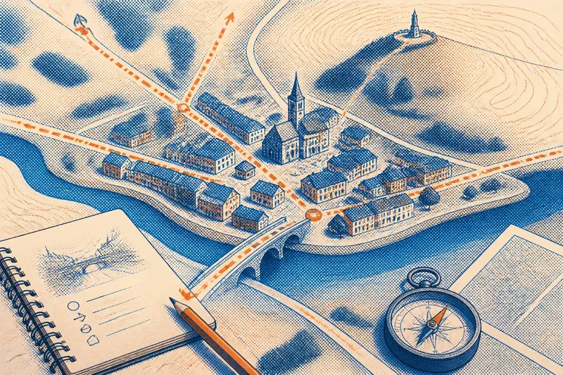
At the edge of a northern town, a bridge may feed straight into the main street while a church tower rises above the roofs. To read why a town centre sits where it does, trace its connections to a crossing, nearby water and higher ground; each clue helps, but none tells the whole story alone.
Think of the centre as a knot in a piece of string. Roads, paths, waterways and slopes pull toward it in different ways, and the useful question is which connections the settlement made easiest—and what other clues complicate that reading.
Start with the shape of the centre
Begin with a paper map or an offline map on your phone. Find the oldest-looking cluster of streets, the main civic buildings, or the place where shops and services bunch together. Do not assume the busiest shopping street marks the original centre: newer commercial activity may have shifted along a road or toward a station.
Zoom out until you can see the town and its immediate surroundings. Note the river, stream, bridge, railway, road junction, open slope and any abrupt change in elevation. Contour lines show rising ground; lines packed close together indicate a steeper slope than lines spaced farther apart.
Then look for connections rather than isolated features. A river close to the centre matters differently if a bridge is nearby than if the banks are difficult to reach. A ridge matters differently if streets climb toward it, or if the centre simply lies in a sheltered hollow below.
Trace the routes that reach the centre
Follow the main streets outward in more than one direction. Do they converge at a bridge, meet at a crossroads, or bend around a hill? Notice whether a route continues beyond town or ends at a water’s edge, station, market square or steep slope.
A crossing can gather movement because people and goods must pass from one bank to another. The bridge itself may be recent, though, and a road junction may have developed after the original settlement. Treat the present route as evidence of current connection, not proof of the town’s first purpose.
If you can walk the area, observe the approach from each side. A street that looks central on the map may feel secondary on foot if a railway embankment, busy road or sharp incline interrupts access. The walk shows how movement works now, while the map offers clues to how the settlement may have taken shape.
Read the riverbank as both resource and boundary
Look for how buildings meet the water. A quay, old warehouse frontage, riverside path or bridge approach points to a working relationship; a broad green strip or flood barrier may signal that the bank is kept open or managed as a hazard zone. A river can offer a route and a resource while also dividing streets or restricting construction.
Check whether the centre sits beside a bend, at a confluence, or near a place where the river narrows. These settings may help explain why a crossing or landing point became useful, but their value depends on local conditions. A shallow-looking reach on a map does not tell you whether the river was easy to cross in another season or an earlier period.
Imagine an invented town whose market square lies a short street from a bridge, while the riverfront below it is now a public path. The bridge approach and square suggest a meeting point between through-traffic and local trade; the path alone cannot establish whether the bank once held docks, workshops or open ground.
Compare the centre with higher ground
Find the nearest hill, ridge or raised terrace, then check which streets climb toward it. A town centre on higher ground may have a broad view or drier footing, while buildings gathered below a ridge may be sheltered from exposure. Treat these as possibilities to test against the layout, not ready-made explanations.
Look for older-looking buildings, a cemetery, a defensive-looking earthwork or a prominent public building on the slope, but do not treat any single landmark as the settlement’s origin point. It may have been built later, or serve a district beyond the centre. The more useful clue is a pattern: routes, buildings and open spaces repeatedly favor the same rise.
On a walk, compare the view from the centre with the view from higher ground. Does the slope overlook a crossing or junction? Do roads avoid the steepest face? A ridge can orient the town and shape approaches even when no important building stands on top.
Which clues help explain a town centre?
Does a bridge prove the town began as a crossing?
No. A bridge shows that crossing the river matters to present movement, but the structure may have replaced an older ferry or arrived after the settlement had already grown. Look for routes and activity on both banks before making a stronger inference.
What does a town centre beside water suggest?
It suggests a close relationship with the river, but that relationship could involve transport, work, water access, drainage or simply a boundary. The bank’s paths, buildings and street connections help distinguish among these possibilities.
Can higher ground explain why the centre is where it is?
It can be part of the explanation if routes, older building clusters or public spaces also favor the rise. A hill visible from town may be only a landmark, so compare its position with the street pattern rather than assuming it shaped the settlement.
Check each clue before forming an explanation
Use a paper or offline map, a notebook and, if available, a historic map or local interpretation panel. For each feature, record what you can see and decide what to investigate next:
- Observe whether several streets meet at a bridge; if they do, consider a crossing’s role in current movement, but compare historic maps before suggesting it shaped the town’s beginnings.
- Observe whether routes and buildings appear on both riverbanks; if they do, examine how the banks connect, but if activity is concentrated on one side, check whether access or terrain limits the other.
- Observe whether buildings, paths or a quay face the river; if they do, consider a working or transport connection, but if the bank is mainly open space, look for signs of later flood management or public access.
- Observe whether streets climb toward a ridge or terrace; if they do, compare their routes with the slope, but if they avoid the steep face, consider whether the terrain directed movement around it.
- Observe whether a railway embankment, busy road or sharp incline interrupts a route; if it does, mark that approach as less direct on foot, but compare another route before judging the centre’s overall accessibility.
- Observe whether a historic map shows the bridge, street pattern or building cluster at an earlier date; if it does, use that evidence to refine the timeline, but if it does not, leave the feature’s age unresolved.
For an invented example, say you find a compact centre on a low terrace, a bridge at its edge, and a steep road climbing toward a church on the ridge. First, mark the bridge, terrace and church on an offline map; next, walk or trace the street from the square to each feature and note where the slope changes; then compare the layout with a historic map or interpretation panel. If the older map shows the centre before the present bridge, record that the crossing may have changed later rather than caused the original location; if it shows the bridge and centre together, note the connection but leave its precise influence open unless other evidence supports it. Either way, the resulting account distinguishes visible connections from what remains unknown.
Write your reading in layers: describe what the map and walk show, say what those features may have made convenient, and note what remains uncertain. That careful distinction makes a town centre’s location easier to understand without asking a river, crossroads or ridge to explain more than the landscape can reveal.